Halloween in our neighborhood

Halloween has come and gone, and I took my two big kids out around the neighborhood in search of candy and community. We walked the length of our street and visited every house, but rather than go down to the next street and do the same, as we did last year, we went back home and picked up the bike so that we could go a little farther.

 
All-black costumes

Over the last few weeks, as we’ve biked around the neighborhood, the kids had noticed some houses where the residents obviously get really into Halloween. Not unsurprisingly, they were interested in visiting those houses on Halloween night. They were too far for us to go to every house along the way, so we decided to take the bike, and visit a few spots in our neighborhood.

I was a little sad, picking and choosing to go only to the houses with the great Halloween decorations. What I love about Halloween is the community, the way every kid in the neighborhood is out and about, and most of the parents as well. It’s an excuse to knock on every door and exchange a few pleasantries. You don’t even need a costume or a pumpkin to participate – just a bowl of candy and a welcoming porch light. Perhaps those undecorated houses are the most important to visit. That might be the lonely person who would love to admire children in costume.

We get some trick-or-treaters at our house, but not many. We live at the end of the block, and around the corner is a slightly busier street that has very few street-facing houses. Perhaps the door density on our corner isn’t high enough to attract kids for efficient candy gathering. The street we went to visit, only a few blocks away, has a consistent, continuous density of doors, and there were lots of groups of kids out and about.

This street has no sidewalks, but the street is narrow, and mostly quiet, so we are comfortable walking and biking on in the street every day, not just Halloween. We saw only a couple of cars while we were out tonight.

The bike was a good solution to the problem of wanting to go a little farther and a little faster than we would walking. It would have been easier if we didn’t need to wear helmets: each stop meant gloves off, helmet off, hat on, so we ended up walking more. The bike itself didn’t interfere with the magic of the night the way a car would. We could still greet our neighbors and slip in and out of driveways as needed.

Then we rode back on the arterial because we needed to get back for dinner, and we saw lots of cars and no people. Not surprising; that street is toxic every day of the year.

Walking Routes to Bellevue Have Gone from Bad to Nonexistent

I ran down to Bellevue today with the stroller as a cargo hauler for stops at Uwajimaya and Total Wine, and wow are things in bad shape.  I don’t think I can make this trip anymore until things settle down.

Here are the blockages that I know about from this trip:

bmap1

120th Ave (location “A”) is completely closed to cars and people.  It’s a giant construction site with machinery everywhere.

124th Ave (location “B”) is a pretty terrible street to begin with.  Sidewalks are mostly missing.  It has large shoulders that one might use, but a lot of them are taken up by trucks.  And some of the few stretches of sidewalk are closed (in the distance you can see a truck blocking the right-side shoulder):

I don’t have a lot of optimism for the Spring District’s transit/bike/walk friendliness.  One of the exits is mostly complete:

The fence is at the existing sidewalk location, so the intersection is going to be huge.  Multiple exit lanes will help ensure car dependence in the area.  And it doesn’t look very good for bike infrastructure.  But I suppose I digress…

116th Ave has no access at all from the north or east because of the intersection at Northup and the other 116th Ave (location “C”).  Zooming in:

bmap2

The northwest corner of the intersection is completely closed to pedestrians as well as the sidewalks leading to it.  This means the crosswalks along the north and west sides of the intersection are unusable.  There isn’t a crosswalk or a signal along the east side of the intersection.  And if you try to go an intersection to the east, you’ll then discover that the south side of Northup doesn’t have a sidewalk.  You might be able to stumble through construction cones and gravel.  (It eventually will have a sidewalk, but a future sidewalk doesn’t make for a very good detour today.)

[Update: September 14th, 2016:

I went back and looked at that south side of Northup again.  There is a temporary path on the shoulder that is guarded by traffic pylons.  One could walk through here.  When I looked during my previous trip, it didn’t register as a possible route.  One could probably get a single stroller through, but a double or a wheelchair would be difficult.  Here are some pictures:

If you come down 24th, then there is a detour sign pointing this way, but if you come down 116th from Kirkland, then you get this confusing sign:

The busy intersection doesn’t have a crosswalk to the left of the picture, and to the right is the wrong direction.

]

The end result of this is that 116th, 120th, and 124th are unusable.  The next crossing to the west is at 108th (a half mile west and you have to backtrack north).  The next crossings to the east are at 130th and 132nd (almost a half mile east), which also have intermittent sidewalks but hopefully no construction.

The hope for the area is supposed to be the ERC (Eastside Rail Corridor), which Kirkland, Bellevue, and King County have all shown interest in opening to people (especially Kirkland with the CKC (Cross Kirkland Corridor)).  However, at this point it looks like this stretch is going to be held hostage by Sound Transit for years or decades.

In other words, don’t try to walk in Bellevue.


How to walk for your groceries with kids

Shopping, unencumbered by children, for one or two people is no problem. You may have done it yourself in college (I did). You can take a backpack and carry a few grocery bags and it works without too much extra planning. If you also need to take a child or two or four with you, grocery shopping gets more complicated. I’ve shopped with most combinations of small children, and can tell you how to do it.

If you have one baby.

Grocery shopping with one baby is easy now, but in the early days it certainly was not. With one baby everything is new and everything takes adjustment. But you can do it! I have always worn the baby, as worn babies are generally happy. At first I wore my daughter on my front and a backpack on my back, but as she got bigger that needed to change. One day I realized that I just didn’t have it in me to carry her and a gallon of milk. So I bought a wire grocery cart at the hardware store across the street, and then realized that I couldn’t carry her, the unassembled grocery cart AND the groceries all at once. The groceries waited until the next day.

Let me tell you, that grocery cart was life-changing. I’d always walked to the store, but now I could see how I’d feed my family as it grew. Going to the store is not (usually) a chore, it’s an outing, a little exercise, and a change of scenery on cranky days. It’s something I don’t have to save for when there’s somebody else to watch the kids. I can get the grocery shopping done with them. On good days I teach them how I choose things in preparation for them doing the shopping themselves. On busy days we just get our things and go.

We have no pictures from those early pre-smartphone days when we didn’t obsessively document the minutiae of everyday life. Here’s a more recent one.

We’ve lined our shopping cart with a piece of foam camping sleeping pad – it’s waterproof and dries quickly. We have a couple of bags that fit nicely side-by-side in the space. They are very worn, but I haven’t found anything else that fits so nicely! We bag heavy things in the lower bags and pile lighter things on top. Sometimes it takes a little rearranging after the bagger loads the bags.

One baby and one toddler.

After the birth of our second child, our oldest was two-and-a-half when Mark went back to work and I had to do the shopping by myself with both of them. She walked to the store and I wore the baby, holding her by one hand and the grocery cart in the other. At the store I put her in the seat of the store cart and left mine stashed out of the way near the checkout area. If your toddler doesn’t walk or can’t be trusted, see “two non-walking children,” below.

Toddlers and up of whatever number.

Once the kids are able to walk with you and behave in the store, it really doesn’t matter how many you have. A wire grocery cart is still essential, and they might pull it for you (at least when it’s empty). They also might fight over who gets to pull it. I’m really looking forward to sending my kids to the store when we are out of yogurt, and it doesn’t have to wait until they are 16 and can drive!

Two newborns.

This is the trickiest situation I’ve had to handle, but it can be done. I wore one and used a stroller for the other. The best situation would be a city stroller with an enormous storage basket, but I didn’t have one, I just had a stroller that took the infant carseat. I put as much as I could in the small storage basket and tied a couple of bags to the handle. We shopped often because it was something to do.

We were quite a sight in those days. I frequently wore one, held one in one arm, and pushed the empty stroller around the store with the other hand. My big kids (aged three and five at the time) pulled our groceries as we shopped with small shopping baskets on wheels.

Two non-walking (either by your choice or their ability) children.


Bonus: nap-fighting toddler sleeps while you get your work done!

I learned this tip from a friend who oldest two are close in age, and we’ve used it extensively with twins. I wear one baby and push a double stroller with the other baby in one seat. After shopping, we fill the other seat of the stroller with groceries. I frequently stash the stroller out of the way in the front of the store and use a shopping cart with the second baby in the seat while we are in the store.


also works for paint


and pumpkins

Our twins are now toddlers, and they love to walk to the store. I only walk with one at a time because I can’t hold both and the shopping cart all at once. The other still rides on my back. We use the “one baby and one toddler” method as described above, and the big kids can be trusted (with reminders) to stay nearby while we walk across the street and across the parking lot.

“I want to walk on the lellow!” (curb in the parking lot on the way to the store)

Why Don’t the Sidewalks Line Up?

I was running through Kirkland the other day and stumbled through an awkward placing of sidewalk ramps at a street crossing (NE 80th St and 131 Ave NE).  I went back later to figure out what was going on, and here is what I saw:

Kirkland appears to be changing to use more directional curb cutouts rather than a slope down to a single centralized one.  Here’s the old sidewalk, at least until Google updates the image:

I took the double stroller to test it.  At least the sidewalk is wide enough to make the turn, but it’s kind of annoying that there’s such a sharp turn at all.

They’ve also added a cutout on the other side of 80th (so to the right in the above photos), and here is what that crossing looks like:

But note again that the cutout, including the textured surface for the blind or visually impaired, doesn’t point in the right direction!  (I then spent a day paying attention to these textured surfaces and it seems to be standard practice for them to point in random directions.)  So what’s going on?  It appears that this is simply another problem caused by having large turning radii for vehicle turns.  Using a high-tech diagram:

crossing-distance

In the left diagram we have a large turning radius for the roadway.  The desire line for pedestrians would be the straight line continuing the sidewalk – “A”.  This, of course, has a quite large crossing distance, and a curb cut would be almost 90 degrees off of the correct direction.  The shortest crossing distance, which would be perfectly aligned with a curb cut, would be “C”.  However, this is also the largest deviation from the straight-line path.  Worse, it would make pedestrians less visible, and since the curve encourages high speeds, it might be quite dangerous.  So in the end the design is forced to compromise with something like “B”.  In the right diagram with a tiny turning radius, the desire line has the shortest crossing distance and gets a properly aimed curb cut.

As another demonstration of the crossing distance, in the crossing of 80th there is almost an entire lane of distance in the road before actually reaching the travel lane.  Part of this is the bike lane, but part is due to the sweeping curve for the turn.

Just down the street (NE 80th St and 131 Ave NE), there’s another bizarre example:

Here they put a single curb cut at 45 degrees from the sidewalk.  This splits the distance between the crossings to the east (towards the camera) and the north (to the right in the picture).  However, they didn’t bother to put a crosswalk to the north, and they certainly didn’t put one diagonally across the intersection.  Then they used a ramp approach on the side with no crosswalk and a full curb blocking the walking path on the crosswalk side!  In the end, the travel path is mostly straight, but (coming towards the camera) involves turns to the right, left, and right and care to not clip a stroller wheel on the curb.

Even better, these are both within a few blocks of an elementary school.

Some More Thoughts on Bicycling in the Netherlands

I will try not to be too redundant with Michelle’s great summary of bicycling in the Netherlands, but one can’t travel from a place with sporadic, questionable bicycling infrastructure to the world leader and not say anything!

But first I do have to repeat just how amazingly pleasant it is to go anywhere.  Washington Bikes has been asking for people to write about their favorite ride or destination.  Mine is easy and too short for a blog post, though Michelle is now challenging me to do so.  It’s our church because it’s the only place we can go on neighborhood streets.  It’s pleasant though crossing the collectors still reminds one of the car-centric nature of everything.  The grocery store would almost be on the list but (1) it’s close enough that we walk, and (2) even it involves crossing an arterial, which is simply awful.  Every ride in the Netherlands was like the ride to our church, except better.

Second, they get it.  The planners/engineers get it.  The people (bicyclists, drivers) get it.  This isn’t news to anyone, but it’s hard to really understand what this means until one goes there and sees it.  The infrastructure just works, and we rode a pretty big range (from neighborhood streets with no separation to paths basically along highways).  There is cooperation between modes.  If a car comes up behind you on a neighborhood street, the driver doesn’t come up close or honk or any of that nonsense.  And when (and if) you get a chance, you let them through.  In the US, almost every moment is claiming space and self-defense to the point of forgetting that people might actually be able to work together.  There were many times where I was comfortable where I wouldn’t have been with the identical situation back home.

One design point from this: intersections are always at least as protected as the roads leading to them.  Normal bike lanes lead to protected intersections (and “protected” here means buffers and separate signals designed for the intersection, not cookie-cutter copies of the “protected intersection” graphic/video going around these days).  We’ve got this backwards where we seem to be fixated on the roads and often neglect the intersections.  Here’s an extreme example of no infrastructure leading to a separated path (though to be fair this is a pretty quiet street hitting a major one):

Third, it’s hard to imagine how many bikes there are.  Pictures and video give a pretty good idea of this.  They’re everywhere, and people don’t run into each other in intersections and plazas.  Seeing the sheer number led me to realize a number of things about handling it.  Bikes on buses?  Not where we were.  It simply doesn’t scale; bikes are too big (except folding ones).  So while it can be handy here and might help attract the next new wave of riders, I wonder how good of an investment it is.  (I don’t know how expensive those 2-bike to 3-bike conversions on the buses were, so maybe it doesn’t matter much.)  On trains?  Yes, but it will cost you 7,5€ (about US $8.25) one-way, so it’s for special occasions.  Then there’s parking.  The train stations are known for having lots of very good parking, but things get interesting in other places.  We’ve gotten very picky about our parking here, but our solutions (like widely spaced staples) take way too much space.  In dense areas, there needs to be a row (or rows!) of bikes pretty much touching all the way down the row.  In fact, often it takes some luck to find anything to lock to at all, so a lot of just wheel-locking is done.

In fact, I think it might be safe to say that the law of induced demand, which we love to refer to when discussing the expansion of highways, applies to bike parking.  The Delft train station houses a lot of bikes overnight.  Grocery store racks were over half full after closing.  It’s a bit annoying and feels wasteful, but it still comes out way ahead compared to space for car parking (not to mention the road space to get the cars there).

Last is pedestrian infrastructure.  In city centers things are fine because pedestrians (and bicycles) pretty much go everywhere.  Busy roads will have separate bicycle and pedestrian paths.  At the other end, it doesn’t really matter in the quietest places.  However, we found the middle area to be remarkably inconsistent.  Sidewalks would end without warning.  This picture from the Delft/Rijswijk border shows the priorities pretty nicely:

priorities on a narrow bridge

priorities on narrow bridges

The bike path continue on both sides.  The car lanes are reduced to a shared single lane.  From the camera’s view, the nearest part of the road only has a pedestrian path on the right side.  The bridge only has a pedestrian path on the left side.  (And unfortunately we were then turning right immediately after the bridge so we would have to cross back.)  And well back behind the camera, the pedestrian path flips sides again.  On the bright side, the merge point provides a pedestrian island.  And more importantly, the overall culture of careful driving trumps it all and makes it work out.

Jaywalking a Huge Intersection?

I noticed something rather unfortunate while running through the 520 trail crossing at NE 40th St the other day.  I’ve written before about all of the conflicts at the intersection.  It turns out that the number of conflicts isn’t necessarily the lowest when the crosswalk signal is green.  I suppose I should add a disclaimer that readers should make their own decisions about the safety and legality of any maneuvers, which is probably further indictment of how our transportation systems aren’t designed for people, but I digress…

This depends a lot on the traffic levels, which mainly depend on the time of day.  This observation was from attempting to cross southbound on foot in the morning after the main commute, so traffic was light.

To the intersection:

(And note that right now the embedded image is old but if you click on the larger Google map you can see the result of the recent construction.)

The relevant change from the construction is the pedestrian island.  It’s small if you’re stuck there and creates a bottleneck for cyclists, but it can make the crossing more manageable.  It means that only the first half of the street needs to be clear to begin a crossing.  Previously, the intersection was simply too large for judgment.  Now, if one reaches the intersection outside of a pedestrian green (which is likely since the green is about 3 seconds long), one only needs to look back and left to find a clear opening to the median (plus whatever quick scan for wrong-way traffic and the like).  In the middle of the countdown, this might mean getting temporarily stranded in the median as the light changes.  Right after the countdown (during light traffic), the off-ramp will have cleared and a few cars will proceed from the east.  Then the light will stay green for no cars for a while.  Visibility to the east isn’t perfect since the traffic comes up over the bridge, but often this is a time where there are no cars on the off-ramp or headed westbound.  Contrast that to waiting for the pedestrian green, which gives enough time for someone to show up:

There is usually a driver waiting for an opportunity to turn right on red when the cycle changes to green for the off-ramp and trail.  This driver often won’t look and would run over anyone entering the intersection immediately.  Unfortunately, once this car has cleared, the trail will already be on the countdown timer, so legally it is impossible to cross.  The next car will be in a better position to see the trail traffic and usually, but not always, will wait.

In fact, it gets better:

After this, the issue is traffic that is approaching the intersection during the green light.  They will be moving at highway speeds and since 40th is so wide they can physically navigate the turn at high speed as well, and some do.

The pedestrian green is the only time that traffic can make the turn at high speed.  (Well, perhaps overlooking the possibility of an exiting car completely blowing the stop sign at high speed isn’t so wise, but a red is better than a green.)

This gets one to the median, where one might find the following:

At the median, there might be a car blocking the crosswalk in the first lane of eastbound traffic.

[Edit: The signal phasing has changed so that the left turn onto the 520 on-ramp is now at the beginning of the east-west phase rather than the end.  This means that the below “first half” and “second half” no longer apply, and the north-to-south flow of somewhat less conflict no longer exists.  I’m not planning on writing about south-to-north, and the real point here is describing how pedestrian/bicycle lights are not designed for pedestrians’ or bicyclists’ safety, let alone convenience, so I’ll leave the rest of this up.]

During the first half of the east-west traffic phase, such a car will leave.  Otherwise, things are no worse than crossing with the signal.

When traffic is light, then as with the westbound traffic, the few eastbound cars will clear out early in the long green light, leaving a clear second-half crossing.  With no cars waiting to go straight, the right-turning drivers’ vision isn’t blocked:

Lastly, it is common for a driver in the right-turn lane (so, the last lane to cross for southbound pedestrians and bicyclists) to blindly pull through the crosswalk before looking for anything.  Always slow and peek around the cars in the next-to-last lane.

The second half of the east-west traffic phase gives a green light and left-turn arrow to the westbound traffic.  Often, due to the multi-intersection signal, more cars show up from the east for it.  If one has made it to the pedestrian island, then the drivers blocking the remaining crossing will have a red light, whereas the new traffic would block a full crossing of the street.  The right-turning drivers won’t be looking during the pedestrian red, but they aren’t looking during the pedestrian green either.

A side effect of this is a quicker crossing, but that isn’t really the point.  And if traffic is heavier, one can do the normal wait for the green light conflicts.  Or maybe WSDOT and Redmond can remove the conflicts from the pedestrian green someday…

Minimalist Shoes

I’ve been walking and running (and I guess cycling) in minimalist shoes for a few years now, so I thought it would be worthwhile to share my experiences.  The timing seems right, too, as I’ve just hit 1500 miles in my first pair that worked for me.  I’ll cover why I changed, what worked and didn’t, and how I look at shoes now.

Continue reading

Crossing NE 40th St on the 520 trail in Redmond

To be honest, I don’t recommend it.  This intersection is not designed for people despite the large number that walk and bike through it, and it’s only a matter of time before someone is hurt or killed.  But here’s what you’ll find.

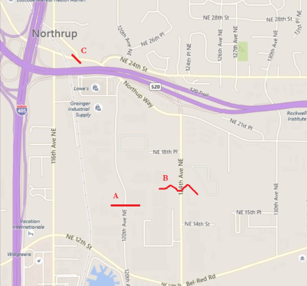
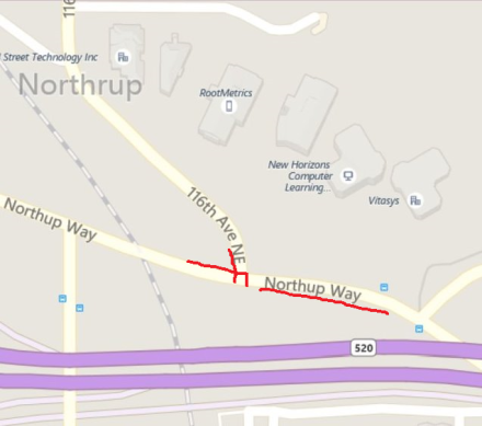
First, let’s orient ourselves:

Yes, that’s a lot of road.  The north side of the intersection is a 520 off-ramp.  The south side is a 520 on-ramp.  The trail runs along the west side of the intersection.  Many are going to Microsoft, which often means heading east along 40th.  The south side of the bridge has a fairly wide ped/bike path.  The north side has a narrow sidewalk.  The bridge at 36th is much nicer to use since there isn’t a highway interchange.  The bridge at 51st has no bike facilities.  That intersection has most of the same problems as at 40th.  However, it can be used to access the northern reaches of the main Microsoft campus.

The (north-south) trail crossing is given an approximately 3 second green signal at the beginning of the off-ramp (facing south) vehicular traffic’s green light.  There is then a 30 second countdown where it is illegal to enter the intersection on foot or bike, but then it’s an entire cycle until the next 3 second chance.  Most ignore this law.  Drivers often assume it is followed.

There is no north-south crossing on the east side of the intersection.

The east-west crossing on the south side is given a slightly longer green signal while the east-west vehicular traffic also has green.  The green and ensuing countdown are shorter than the east-west vehicular green light.  There is also a period where the eastbound traffic is stopped and a left arrow is given for westbound traffic to turn onto the on-ramp.

The east-west crossing on the north side is given a green signal during the entire east-west vehicular green light.  However, this is only really useful on foot.

Right-turn-on-red is allowed for both of the possible right turns and is the biggest problem.  Drivers turning right onto the on-ramp often stop on the crosswalk rather than the stop line, assuming they stop at all, before looking for vehicular traffic blocking their turn.  Drivers turning right off of the off-ramp will pull far enough forward that they no longer can see people waiting on the corner.  Then when the light turns green this right turn conflicts with the trail crossing.

Crossing southbound:

There is usually a driver waiting for an opportunity to turn right on red when the cycle changes to green for the off-ramp and trail.  This driver often won’t look and would run over anyone entering the intersection immediately.  Unfortunately, once this car has cleared, the trail will already be on the countdown timer, so legally it is impossible to cross.  The next car will be in a better position to see the trail traffic and usually, but not always, will wait.  After this, the issue is traffic that is approaching the intersection during the green light.  They will be moving at highway speeds and since 40th is so wide they can physically navigate the turn at high speed as well, and some do.

At the median, there might be a car blocking the crosswalk in the first lane of eastbound traffic.

Lastly, it is common for a driver in the right-turn lane (so, the last lane to cross for southbound pedestrians and bicyclists) to blindly pull through the crosswalk before looking for anything.  Always slow and peek around the cars in the next-to-last lane.

Crossing northbound:

Of course northbound has the same set of obstacles as southbound, though they present themselves a bit differently.  When the crosswalk signal turns green, cars in the right turn lane will be seeing the first break in traffic from the cars turning left onto the on-ramp (since the light has just turned red), so expect one to make this turn without looking for trail traffic.  On the other side, cars may be moving after the southbound trail traffic has cleared, and the drivers will be eager to go.

[Edit: The signal phasing has changed so that the left turn onto the 520 on-ramp is now at the beginning of the east-west phase rather than the end.  In practice this means the right-turn lane onto 520 might be empty at the beginning of the north-sound phase, so it sometimes removes a conflict.]

Crossing east-west:

If you are a pedestrian going between the northwest and southeast corners of the highway exchange, you can avoid the two miserable crossings by using the north side of the bridge.  The crosswalks at 156th are much more pleasant.

The south side’s east-west crossing has the problem of conflicting with right-turning traffic onto the on-ramp.  (“Conflicting” here means both groups have green lights at the same time.)  So the green pedestrian signal is hardly a promise of safety.  On top of this, drivers find all sorts of ways to abuse the left turn onto the on-ramp.  A lot of it stems from them getting blocked from making the turn while they have the green and then just doing it whenever the blockage clears.

Commentary:

It’s a complete embarrassment that WSDOT allows right-turn-on-red at this busy intersection.  I can’t take anything any of their officials say about safety seriously while they let this abomination continue.  The city of Redmond should be pushing hard for this as well but does not.  Stopping right-turn-on-red wouldn’t be a complete fix, but it would help a lot.  Stronger measures should probably also be taken (e.g., raised crosswalks, separate phase for pedestrians/bicycles), but they will never happen because WSDOT prioritizes the movement of cars to the meter on the on-ramp or the next intersection where they will need to stop again anyway.

There were recent small modifications to the intersection.  The turning radii for the problematic right turns were slightly reduced.  However, both right turns end on such wide roadways that it hardly matters.  Some bicyclists have reported that the geometry is somewhat improved so that they are in a better position to be seen before entering the intersection.  This isn’t something that I’ve noticed, but hopefully it’s a little better.  The new median seems to only provide a chokepoint for the trail traffic as well as confusing a few drivers about where the stop line is.

The long-term hope is a tunnel under the intersection for the trail and a separate bridge over 520 for access to Microsoft.  These are expensive but probably the most realistic option.  And they should be quite nice to use.  Unfortunately they will result in this intersection getting even crazier, so pedestrians will be forced to the tunnel or 152nd and vehicle collisions will probably increase.

Vehicular Pedestrianing

Fight for Your Right to Pedestrian Properly!

The right of pedestrians to travel properly and safely is disappearing. If you don’t fight to preserve it, it will disappear.

Since 1912 and more so in the mid-twenties, American society has disapproved of lawful, competent pedestrianing. It was then that pedestrians were confined to crosswalks, removing them as a main mode of transport and prohibiting them from exercising the full rights given to drivers of vehicles. Then, new laws prohibited traveling away from the edge of the roadway, from traveling outside of sidewalks, or for using the roadway at all if a path usable by pedestrians was nearby. The sidewalk system was devised by motorists to provide the physical enforcement of these laws that, motorists think, make pedestrianing safe by keeping “their” roads clear of pedestrians. The environmentalists were suckered into this bogus safety argument and now demand sidewalks to make pedestrian transportation safe and popular. With the government spending more and more money on sidewalk and path programs, lawful and competent pedestrians are being more and more limited to operating on paths that are unsuitable for lawful and competent pedestrianing.

Most of the rest of this blog post explains the advantages of lawful, competent pedestrianing and the engineering and safety defects inherent in doing anything else. That is all support for what must be done now, fighting for repeal of the three discriminatory anti-pedestrian traffic laws. Vehicular pedestrians and path pedestrians must join forces to reform the national policy for pedestrian transportation so that it serves pedestrians rather than serving the convenience of motorists.

Continue reading

Perceived Distance (or Time)

I completely forgot to write about what was probably the most interesting part of my little shopping trip earlier today.  The reason that I even made the stop, besides the obvious errand grab, was that I could “take advantage of already being near the Safeway”.  This store is barely more than a half mile from my office!  Sure, it was an opportunity to save some time, but it felt like this great “don’t miss it” opportunity.  Why was that?

In thinking about it, I’m convinced that it’s because the route is boring.  City designs for pedestrians include getting interesting storefronts right up to the sidewalk rather than suburban setbacks that lead the sidewalks past parking lots.

Here’s the route:

And here’s what you see:

Well, even those construction cones are gone now, and the right side development hasn’t added much.

And when you get to the sidewalk on the left side in the distance, you find that it overlooks a… highway.

I would have estimated this trip at around a mile, maybe a bit more.  I’m actually pretty good about these estimates from running around, and I would have missed this by a factor of two.  And that’s why I haven’t found myself just walking down there.